By Nepal Flying Labs
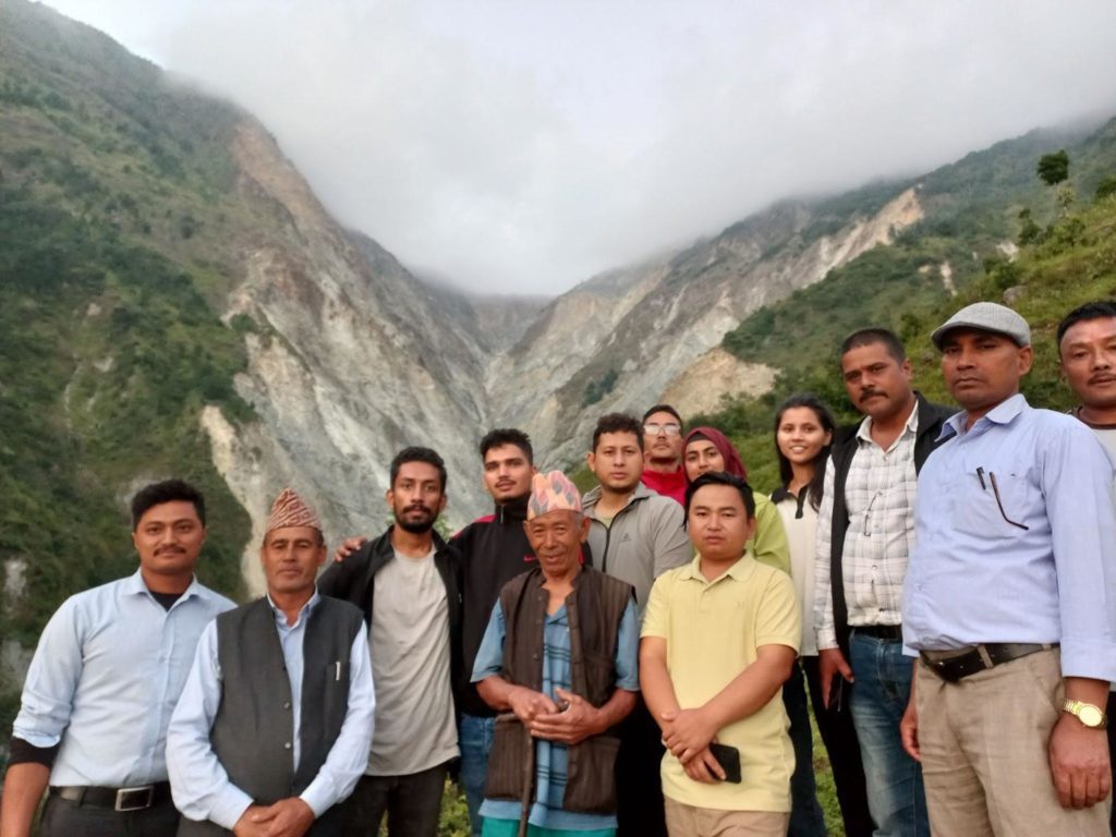
 View of the Ghyapche Landslide
Situated in the lap of the Himalayas, Nepal faces significant geological and climatic challenges, including landslides, earthquakes, and floods. The historical data of the past 50 years from DesInventar and the Ministry of Home Affairs suggests an average death toll of 113 every year. Considering the topography, complex geology, land use patterns, and climatology, geo-hazards like landslides are a recurrent phenomenon.
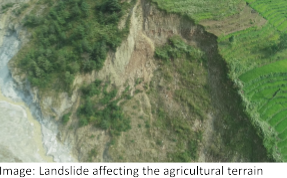
The Ghyapche landslide in Ramechhap is considered to be one of the top 10 largest landslides in the country. Back in 2017, Nepal Flying Labs, in partnership with Medair and WeRobotics, conducted a joint risk assessment mission and conducted the first ever high-resolution aerial survey over the Ghyapche landslide, making it one of the largest landslide mapping missions with drone technology back at that time in Nepal. We documented this work in a blog post within which we also shared a video of the 3D map we produced. This initiative was also later recognized by the AUVSI XCELLENCE Humanitarian Award in 2018. The project was focused on the mapping exercise through the use of frontier technologies but lacked the components of a participatory approach. Further, the resource constraints also resulted in limitations on the project outputs and knowledge products.
A Return Mission for Community Impact
Following the 2018 mapping exercise, we explored potential resources to conduct more activities in the landslide area. Fortunately, a few months ago, we received the Turning Data into Action microgrant from WeRobotics to go back to the landslide area and conduct some technical work—this time focusing more on stakeholder engagement and turning the data into action. To understand the evolving dynamics of this massive debris flow, we collaborated with the Institute of Himalayan Risk Reduction (IHRR), a local DRM research organisation, aiming to evaluate the landslide hazard, estimate the run-out volume, and explore potential countermeasures by conducting a comprehensive run-out analysis and mapping exercise.
The Ghyapche landslide is spread over three administrative wards (Ward No. 3 and 4 of Manthali Municipality and Ward No. 4 of Likhu Rural Municipality, Ramechhap District), covering a massive area of 4.4 square kilometres, which is expected to increase further. It is a deep-seated debris flow landslide that was found to have initially occurred in 1954 AD (2011 BS) due to heavy rainfall. Over time, this debris flow has covered a huge area of agricultural and grazing land.
Our Aerial and Geological Surveys
Considering the terrain complexity and frequently changing weather conditions, the team conducted eight flights with different types of drones. We covered over 5 square kilometres of area with a Wingtra 1 Gen II- hybrid VTOL drone and a DJI Phantom 4 Pro V2.0 drone with a Sony RX1R II 42MP sensor. In addition to photogrammetrics, the team also recorded video footage of the landslide area, covering the landslide and nearby village areas.

 Drone pilots setting up the missions and preparing for the drone flights.
In addition to the aerial survey, the project team also conducted a thorough field visit. Complying with the safety precautions, we marched the transect walk across the crown of the landslides and the areas suffering land degradation. With the geologists in the team, we also studied the landslide geology and morphology to help us understand the factors affecting the landslide. In order to understand the soil properties and assess the soil stability, we collected soil samples with GPS information for laboratory testing. We also observed the piling up of around 4 metres of debris materials at the foot of the landslide, which has been accumulating continuously in the region.
The landslide has been found to be active as there is continuous degradation of the materials due to the presence of the Ranjor Khola. There were huge ground cracks, almost 5-10 metres deep, near the vicinity of the crown of the landslides. Because of the presence of small creeks and rivulets, the region has been found to be highly active and creeping even up to 100 metres, with some pronounced evidence of landmass subsidence. Understanding these dynamics is crucial for predicting future extensions and implementing suitable mitigation measures.
The geological study suggests the presence of local faults and weak and weathered rocks, which are features of terrain instability that make the region prone to creeping and landslides. This synchronous sequence of factors paints a comprehensive picture of the Ghyapche landslide, highlighting the interrelationships of geological weaknesses and their consequential impact on the local environment and communities.


Valuable Insights from Community Engagement
 Group photo after the focal group discussion at Lakuri Danda
The team was also enriched with ground-level information and field experiences from the participatory interactions with the key informants and locals. Senior citizens, government officials, and representatives from the education sector and local community shared their insights on lived experiences, observations over time regarding landslide impacts, and perceptions concerning landslides. The focused group discussions held at Lakuri Danda in Manthali Ward No. 4, Ramechhap, highlighted the impacts of landslides on approximately 250 households. The locals claimed the need for the relocation of at least 100 houses due to the active subsidence in the region. Interestingly, the impact of landslides was observed to be greater during the winter season than the rainy season due to their creeping nature. In addition to this, the dust from the landslide and active flow has also been resulting in pollution during the summer.
Some Wins, Some Challenges
The use of drone technology for aerial surveys and mapping proved to be instrumental in obtaining detailed insights into the landslide-affected regions. The creation of high-resolution orthophoto maps and 3D models facilitated precise calculations of debris volume and enabled the assessment of potential future risks in neighbouring landslide-prone areas. Further, the high-resolution images captured using drones worked as multiple inputs of data, as they also allowed photographic analysis.
 Orthophoto of the landslide in 2017 (left) and in 2023 (right).
However, understanding the landslide dynamics has been difficult due to the challenging terrain. The terrain elevation of the Gyapche landslide region varied from 488 metres to 2080 metres, making it difficult to carry out aerial surveys. The weather-related issues, particularly the fog, added an extra layer of complexity. Similarly, the vegetation cover also varies in the region, thereby making it difficult to detect cracks and abnormalities in high vegetative cover orthophotos.
Additionally, a key issue identified during the participatory appraisal was the creeping nature of the hills adjacent to the Gyapchhe landslide. The current study delves into the active nature of the Ghyapche, thereby identifying the vulnerable regions near the crown and body of the landslide. The small rivulets, creeks, and dynamics of Ranjor Khola have further aggravated the scenario and made the adjacent region creepy and active.
Gyapchhe Appeals for Support in Landslide Risk Reduction
In order to create a risk informed community, it is essential to make the communities aware of the existing risks and landslide dynamics. We developed GIS maps and shared them with the local government for the development of mapboards. However, this won’t be enough for the settlements in the region as it has not been getting sufficient attention for risk mitigation and intervention.
Addressing the increasing threat of landslides requires a concerted effort and sufficient funding for advanced risk assessment initiatives. By investing in these critical measures, we not only safeguard local communities and infrastructure but also pave the way for sustainable development. The time is now for stakeholders, from governments to private organisations to development agencies, to recognize the importance of resources and funding in reducing landslide risks. There is a dire need to intervene through structural measures and also develop the risk-informed communities aligned with the global initiatives of EarlyWarnings4All by 2027.
To visualise and further understand the Ghyapche landslide, we invite you to check out the comprehensive and interactive ArcGIS Story Map we developed. Our hope is that the Ghyapche landslide project will serve as a prime example of the transformative power of technology, community participation, and interdisciplinary collaboration in handling complex geological challenges. The insights we gathered will be crucial in building sustainable development and disaster risk reduction plans in the area as Nepal Flying Labs continues its commitment to creating resilient communities.