A Locally Led, Globally Supported Drone Response to Hurricane Melissa in Jamaica
Jamaica Flying Labs and WeRobotics are bringing together an expanding network of partners to enable rapid, bottom-up collective action.
November 9th, 2025
By Jamaica Flying Labs and WeRobotics

Hurricane Melissa, one of the most powerful storms ever recorded in the Caribbean, struck Jamaica on October 28, 2025, as a Category 5 hurricane with sustained winds reaching 185 mph (297 km/h). Originating off the coast of West Africa, Melissa rapidly intensified as it crossed the Atlantic, bringing catastrophic winds, torrential rain, and storm surges up to four metres high. Jamaica bore the brunt of the impact, with widespread destruction across parishes like St Elizabeth and Black River, while neighbouring Cuba, Haiti, and the Dominican Republic also suffered severe flooding and infrastructure damage.
Despite extensive preparations — including mass evacuations, the opening of hundreds of shelters, and coordinated readiness from disaster agencies — Melissa’s intensity overwhelmed many communities. Several people across the region have lost their lives and thousands are displaced. Power and communication outages continue to hinder rescue efforts, and early estimates suggest losses of billions of US dollars. Governments and humanitarian organisations are leading large-scale relief operations to restore essential services and provide emergency aid. As recovery begins, Melissa has once again exposed the Caribbean’s deep vulnerability to climate-fuelled storms and the urgent need to build stronger, more resilient disaster risk reduction and response systems.
In the wake of Hurricane Melissa’s devastation, Jamaica Flying Labs, WeRobotics, and Esri have redirected our efforts from convening to responding. The first Central American edition of our Drones, AI, and GIS for Disaster Risk Management Conference and Workshop Series — originally planned for early December 2025 in Montego Bay, Jamaica — is postponed to Q2 2026. Together with all conference partners, we have shifted our focus from preparation for the conference to immediate disaster response efforts in Jamaica.
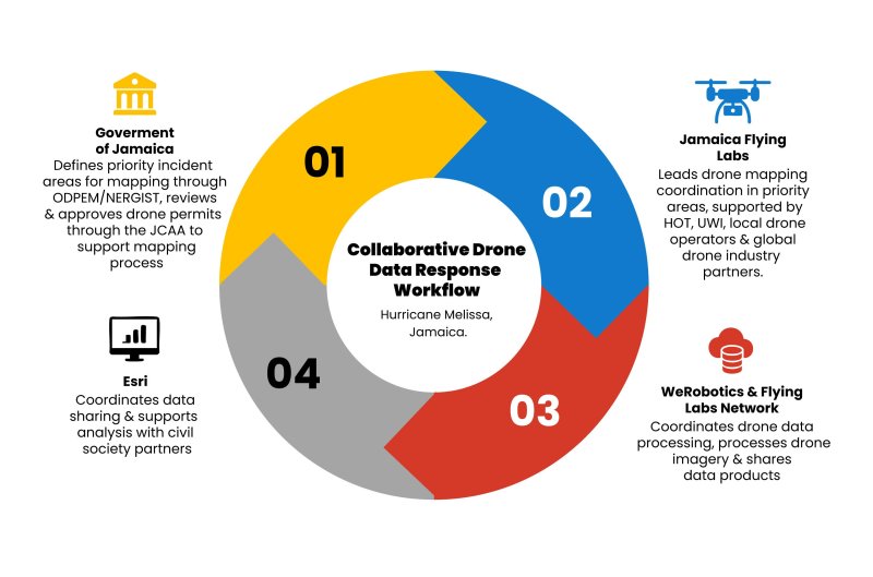
In situations like this, speed and connection are everything. The National Emergency Response GIS team and the Office of Disaster Preparedness and Emergency Management in Jamaica have tasked Jamaica Flying Labs with leading all drone operations supporting emergency response. We have therefore launched a joint response that prioritises coordination and collaboration. Jamaica Flying Labs and WeRobotics are bringing together an expanding network of partners to enable rapid, bottom-up collective action. Just days after the storm, we convened an online coordination meeting with 20+ people to align workflows and mobilise resources.

As well, the Flying Labs Network has rallied in solidarity. Flying Labs from different parts of the globe will be contributing to real-time data processing as drone pilots in Jamaica collect critical aerial imagery. These are Brazil, Costa Rica, and Panama Flying Labs in Latin America; Tanzania, Senegal, Cameroon, and Namibia Flying Labs in Africa; and India, Bhutan, and Nepal Flying Labs in Asia.
With this round-the-clock collaboration, data collected on the ground will be processed globally, and already, technology partners like Esri, DroneDeploy, Wingtra, and Skydio are contributing either their software resources or sending teams with their drones to support this work. These efforts will enable the rapid production of geospatial data products to support government authorities and local communities as they assess damage and plan recovery. Watch the video below to hear how we are meeting this challenge collaboratively and from the bottom up.
You will need to give cookie consent in the Experience option to see this video. Click the cookie link at the bottom right of the page to change your preferences.
This marks the first time that our entire ecosystem — including WeRobotics, the Flying Labs Network, and our partners — comes together for such a large-scale, collaborative drone-aided disaster response, a joint effort spanning continents yet directed from the ground up. It represents a shift in how disaster response is coordinated: through locally led, globally supported collaboration that values local expertise and context rather than top-down, externally driven action.
As we continue to mobilise resources and scale our efforts, we invite funders and partners to join us. We are currently self-funding the majority of our efforts, and so do all the organizations and partners involved, including our technology partners, contributing with in-kind technology and pro bono human resources. Support from funders would go a long way.
Financial support would allow us to expand this bottom-up, collaborative disaster response. In addition, it would allow us to create a blueprint of locally led, globally supported drone/geospatial response to major disasters, ready to be replicated in other countries in the future. Please reach out to us here. In addition to funding needs, we invite organizations who would like to join this collaborative effort with specific expertises to reach out via this form.
Category(s)
Recent Articles
View All »

Team Cameroon's Road to Victory at the First Global Robotics Competition 2025
