The Promise of AI and Why We Africans Need Drone Data in Africa
Drone data is being used to train AI models to detect the types of building one is likely to encounter in Tanzania and other similar countries.
October 14th, 2020
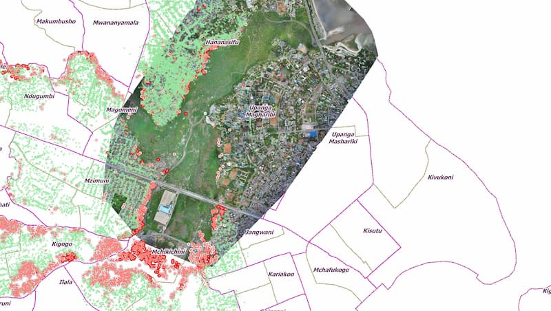
 Household flood extent in the Msimbazi Valley. Survey by Ramani Huria.
The use of civilian drones has increased over the past decade with wide-ranging benefits to local communities thanks to use-case cases that we and others have documented and implemented. A somewhat similar trend is developing with artificial intelligence (AI), so we are working with DataKind to leverage both technologies to help achieve the Sustainable Development Goals (SDGs).
A single 20-minute drone flight gives you 13 hours of manual work to study the data. How can an Urban Planner visualize and count the number of new buildings in Dar es Salaam—a sprawling future megacity in Eastern Africa with some areas growing at a rate of 20 percent per year? Answer: Building footprints from high-resolution aerial imagery. These footprints help plan for new pipelines, emergency vehicle access, solar power installations, and much more, including insights into changes in a particular area. We and our colleagues mentioned the all-important reasons for identifying these buildings at Ramani Huria in this must-read article from the BBC. Enter civilian mapping drones and AI.
The ability for drones to capture on-demand, high-resolution near-ground and cloud-free imagery make them ideal for mapping. One such mapping exercise was the Zanzibar Mapping Initiative, which was the first-ever attempt to map more than 2000 km2 of land using drones. The data collected is being used to train AI models to detect the types of building one is likely to encounter in Tanzania and other similar countries. Thanks to the tireless efforts of our colleagues at DataKind, we now have a working tool that allows us to generate building footprints automatically from drone data. This is the first step towards the next version, which will enable users to perform rapid damage assessments during a disaster response.
The ability for drones to capture on-demand, high-resolution near-ground and cloud-free imagery make them ideal for mapping.
DataKind’s tool is fully automated, meaning that all users have to do is upload drone imagery to the cloud and press one button to run the pipeline. Notably, the resulting building footprints are much smaller than the original imagery, letting users with limited connectivity download the data rapidly. The next step, the actual interpretation of the results by local experts and the formulation of concrete policy recommendations, is the most important part. Why? Because as local experts from Tanzania, we have the local knowledge and an understanding of the local context essential to interpreting the results of AI-derived analysis of drone-generated imagery of Tanzania. We all know full-well the dangers that arise when bias is introduced in AI-algorithms. As local experts, we are best placed to correct this bias, thus ensuring that policy recommendations are based on reliable data and analyses.
We look forward to sharing these tools with other stakeholders in Tanzania and beyond to improve their decision-making and achieve the Sustainable Development Goals through data-driven policies. Having locally-trained analysts directly engaged in applying these tools with key stakeholders remains paramount to ensuring that the right policies are based on the right analysis.
Category(s)
Recent Articles
View All »

Team Cameroon's Road to Victory at the First Global Robotics Competition 2025
