Reaching the Unreached: A Doctor’s Call for Equity
Drones, Data and AI for Health | December 10, 2025
Watch the documentary now to witness Philippines Flying Labs' work using drones to fight tuberculosis in remote communities.
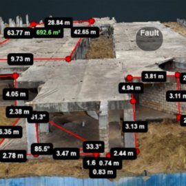
Strengthen Skills in Structural Inspection and Defects Detection Using Drones
October 18th, 2023
Zambia Flying Labs and the Association of Consulting Engineers of Zambia co-organized technical training for 12 professionals in surveying and mapping skills, inspection, 3D modeling, simulation, cost-effective recognition, among others.

Discover the use case
Download

