Preserving Senegal's Mangroves: Aerial Mapping in Somone Marine Protected Area
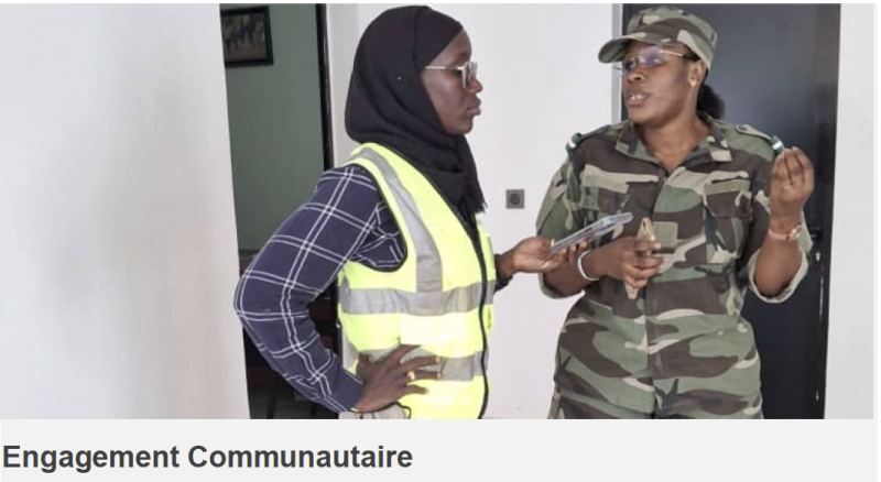
Senegal Flying Labs worked closely with staff, eco-guards, and local residents to ensure the project aligned with their priorities.
August 20th, 2025
Mangroves are one of the most valuable ecosystems on Earth. Found in tropical and subtropical regions, they form a natural buffer between land and sea, protecting coastal communities from erosion, storms, and flooding. Their dense root systems provide nursery grounds for fish and crustaceans, while their trees store vast amounts of carbon, playing a key role in mitigating climate change. Globally, mangroves are recognized as “blue carbon” ecosystems — their capacity to capture and store CO₂ per hectare surpasses that of many terrestrial forests.
In Senegal, mangroves are an integral part of the country’s ecological and cultural heritage. They contribute to food security by sustaining artisanal fisheries, support biodiversity by sheltering countless species, and protect shorelines from the advancing impacts of climate change.
Yet, despite their importance, mangroves in Senegal have faced decades of degradation due to overexploitation, urban expansion, and changing climate patterns. This has heightened the urgency for restoration and sustainable management initiatives.
The Somone Marine Protected Area: A Living Example of Community Stewardship
Located 77 km south of Dakar, the Aire Marine Protégée (AMP) de la Somone stretches across 4,098 hectares, encompassing both the terrestrial area surrounding the Somone River lagoon and extending up to five kilometers into the Atlantic. It is not only an ecological treasure but also a place of beauty and cultural significance, attracting ecotourists and serving as a model of community-based environmental stewardship.
The AMP’s roots trace back to 1999, when women from the four surrounding localities — Guéréo, Somone, Thiafoura, and Sorokhassap — noticed alarming degradation in the mangrove ecosystem that their livelihoods depended on. They began regenerating the area by planting hundreds of thousands of mangrove propagules. In recognition of these efforts, the Sindia Rural Council created the Réserve Naturelle d’Intérêt Communautaire de la Somone (RNICS). In 2020, a Presidential Decree elevated the site to a full Marine Protected Area, strengthening its legal protections and management capabilities.
Today, the AMP is managed jointly by a Conservator from the Ministry of Environment and three governance bodies — the Management Committee, Orientation Committee, and Scientific & Technical Committee — all of which include local stakeholders. A dedicated team of 13 eco-guards drawn from surrounding villages ensures daily monitoring, visitor management, and enforcement of regulations. Alongside conservation, the AMP promotes sustainable economic activities such as ecotourism, artisanal fishing, and community-led environmental education.
Why Senegal Flying Labs Got Involved
When Senegal Flying Labs was invited to participate in the Colloque sur les Écosystèmes de Mangroves, we saw an opportunity not just to share expertise, but to contribute directly to the conversation with fresh, field-based insights. Rather than presenting only theoretical knowledge, we decided to bring real, up-to-date data from a well-known and scientifically significant site: the AMP de la Somone.
In collaboration with Senegal’s Ministry of Environment — specifically its Direction des Aires Marines Communautaires Protégées (DAMCP) — and with the ground support of the AMP Somone’s team, we undertook a comprehensive drone-based mapping and monitoring mission focused on the mangrove restoration areas. Our aim was to provide precise, actionable geospatial data to support both conservation decision-making and community-based management.
The Project
At Senegal Flying Labs, we believe technology alone is not enough — community engagement is essential. In Somone, we worked closely with AMP staff, eco-guards, and local residents to ensure that the mapping process aligned with their priorities and that the results could be easily understood and used for on-the-ground action. This participatory approach strengthens local ownership of conservation outcomes and ensures that technology serves the people most directly connected to the ecosystem.

For the mapping, our team began by carefully planning flight missions using DJI app protocols, dividing the mangrove area into several flight blocks to ensure complete coverage. A risk assessment was conducted beforehand to set optimal drone parameters and ensure operational safety.
We used a combination of high-resolution drone imagery and satellite data:
- Matrice 350 RTK for RGB imagery at 0.86 cm/pixel — ideal for detailed mapping, fine-scale monitoring, and plot-level inventory of mangrove growth.
- Phantom 4 RTK Multispectral for vegetation health analysis at 1 cm/pixel.
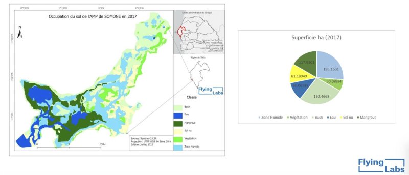
- Sentinel-2 L2A satellite imagery at 10 m resolution for large-scale vegetation monitoring and land cover change detection.
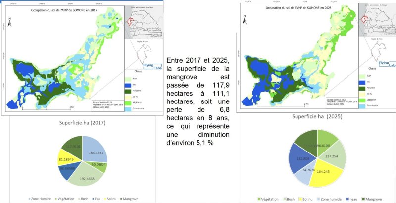
This multi-source data approach allowed us to identify current mangrove extents, monitor changes over time (both degradation and regeneration), and map active restoration zones with precision.


Results and Significance
The data collected in Somone equips managers with the tools to better target conservation and restoration efforts. With precise maps and up-to-date vegetation health indices, they can monitor restoration progress more efficiently, detect early signs of degradation, and plan interventions with greater confidence.
Beyond immediate conservation management, such data contributes to national and global environmental goals. It supports Senegal’s National Greenhouse Gas Inventory and its Nationally Determined Contributions (NDCs) by providing accurate estimates of carbon storage in mangrove ecosystems — a critical component of climate mitigation strategies.
The collaboration in Somone is a blueprint for how drone technology, satellite imagery, and community-based stewardship can work hand in hand for coastal ecosystem protection. Future efforts will focus on expanding such monitoring to other sites, estimating carbon sequestration more precisely, and integrating drone-derived data into broader climate resilience and biodiversity protection frameworks.
Mangroves are a lifeline for coastal communities and a frontline defense against climate change. By combining traditional knowledge and advanced geospatial technology, Senegal Flying Labs and its partners are proving that conservation can be both innovative and deeply rooted in community action.
Special Thanks
We extend our sincere thanks to our partners at the Direction des Aires Marines Communautaires Protégées (DAMCP) within the Ministère de l’Environnement et de la Transition Écologique du Sénégal, whose mission is d’assurer une gestion rationnelle des ressources naturelles et du cadre de vie. We also warmly acknowledge their partners, including SOCODEVI, for their invaluable support and funding of vital restoration and surveillance initiatives that contribute to the sustainable management of our ecosystems.
Category(s)
Recent Articles
View All »

Team Cameroon's Road to Victory at the First Global Robotics Competition 2025
