
Flying Towards Resilience: Using Drones and Earth Observation for Disaster Risk Management in Nigeria
Nigeria Flying Labs Undertakes Aerial Mapping for Flood Risk Assessment in Oke Ijebu, Akure
September 16th, 2025
Executive Summary
Nigeria Flying Labs recently conducted an aerial mapping mission in Oke Ijebu, Akure, to showcase how robotics, drones, and Earth observation technologies can be leveraged for disaster risk reduction (DRR). Flying at an altitude of 70 meters with a front overlap of 70% and side overlap of 65%, our drone captured 370 high-resolution images with a Ground Sampling Distance (GSD) of 1.91 cm/px. Using Agisoft Metashape, we produced a dense point cloud, digital elevation model (DEM), 3D model, and orthomosaic. Subsequent analysis, including Height Above Nearest Drainage (HAND) modelling using QGIS, allowed us to identify flood-prone areas and propose proactive mitigation strategies.
Introduction: From Sky to Strategy
Flooding remains the most frequent and devastating natural disaster in Nigeria, displacing millions and damaging livelihoods. According to the United Nations Office for Disaster Risk Reduction (UNDRR), the 2022 floods alone impacted over 1.4 million people. At Nigeria Flying Labs, we are committed to using advanced technologies to move from reactive emergency responses to proactive resilience building. This project in Oke Ijebu, Akure, represents a practical demonstration of how localised data and geospatial analysis can inform flood risk management strategies.
Our Mission in Disaster Risk Reduction
At Nigeria Flying Labs, we believe technology should serve the communities most vulnerable to climate risks. By deploying drones and applying Earth observation analytics, we empower local governments and stakeholders with actionable insights. Our goal is to map hazards, support planning, and foster resilient communities that are better prepared for the future. Every centimetre of elevation data we gather has the potential to save lives and protect infrastructure.
Flight Planning and Data Acquisition
To ensure comprehensive coverage and high data quality, flight planning was conducted using Google Earth Pro and Pix4Dcapture. The Area of Interest (AOI) was digitised in Google Earth Pro and exported as a KML file. Pix4Dcapture was used to plan and execute the autonomous drone flights. The mission parameters were selected to achieve high overlap and ground resolution, crucial for generating accurate 3D models and surface maps.
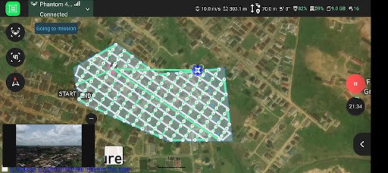
- Altitude: 70 meters
- Area mapped: 14 hectares
- Front Overlap: 70%
- Side Overlap: 65%
- GSD: 1.91 cm/px
- Total Images Captured: 370
Processing Workflow in Agisoft Metashape
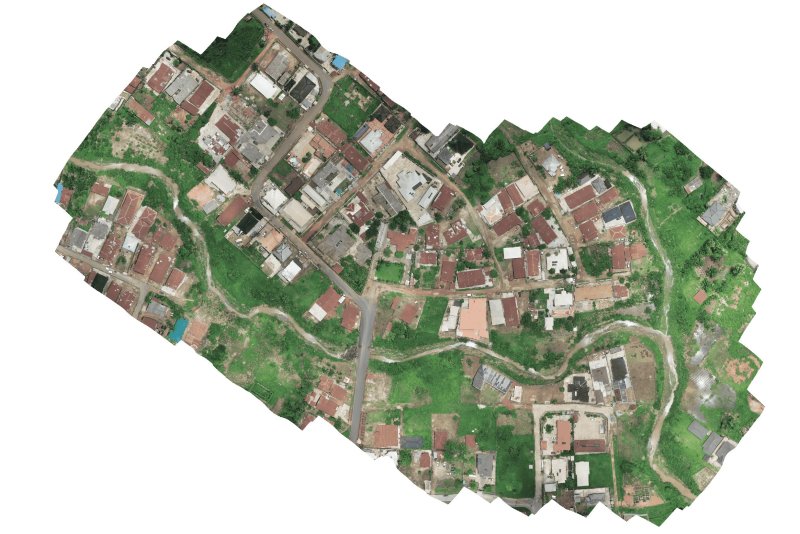
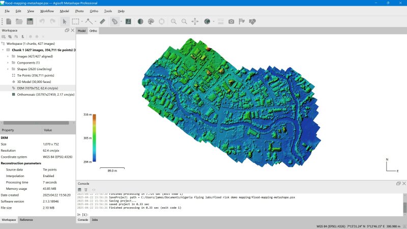
Following data acquisition, images were processed in Agisoft Metashape using a methodical workflow to ensure accuracy and detail. The steps included photo alignment, camera calibration, sparse and dense point cloud generation, mesh construction, DEM extraction, and orthomosaic creation.
The resulting outputs included a detailed 3D model, an orthomosaic, and a DEM with a resolution of 1.91 cm/px, revealing fine-scale topographic features critical for flood risk analysis.
Analysis Workflow in QGIS (GRASS)
- Preprocess the DEM (r.fill.dir)
- (r.slope.aspect)
- Generate hydrological features (r.watershed)
- Calculate Flood-Prone Areas using the topographic wetness index (r.topidx)
- Calculate the vertical distance to the drainage network using SAGA
- Recassify raster into risk zones
- Create map layouts for visualisation
Analysis Results
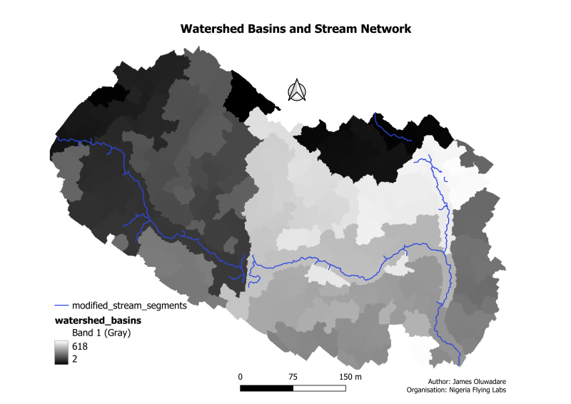
The stream segments, topographic convergence index and height above nearest drainage revealed key micro-topographic features, including depressions, blocked drainage channels, and urban runoff pathways. By applying Height Above Nearest Drainage (HAND) analysis, we classified the area into high, medium, and low flood risk zones.
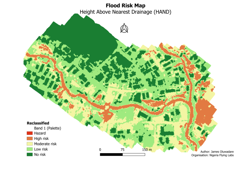
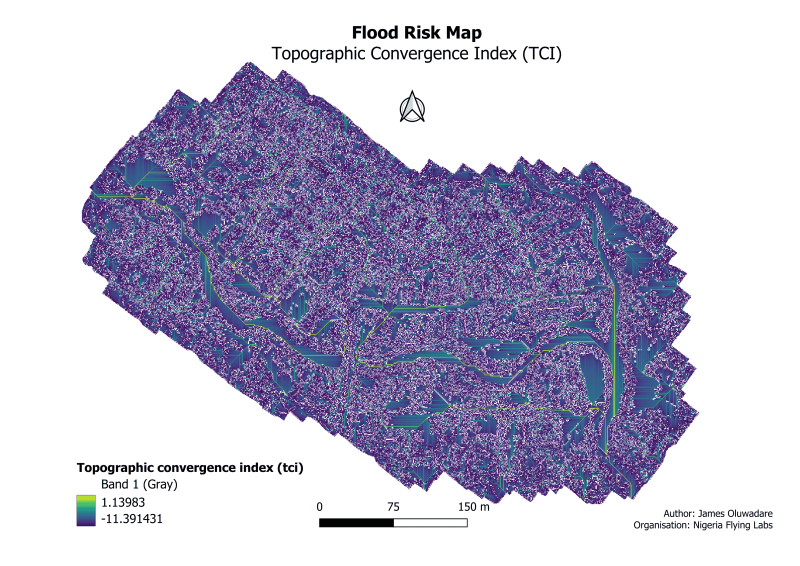
Key Findings:
- Approximately 30% of the study area falls into moderate-to-high flood risk categories.
- Encroachment and blockages in natural drainage pathways are significant contributors to local flooding.
- Urban expansion without adequate drainage planning exacerbates flood risks.
Recommended Interventions
Based on our findings, and with reproducibility in larger areas in mind, Nigeria Flying Labs proposes a mix of structural, ecological, and monitoring interventions to reduce flood risk and enhance resilience.
From a structural perspective, constructing retention basins and upstream check-dams would help to slow runoff and attenuate peak flows. In addition, expanding existing drainage channels and ensuring they are regularly desilted and maintained would reduce the likelihood of blockages and overflow.
Nature-based solutions are equally vital. Establishing riparian buffers with native vegetation along waterways can stabilise soils, reduce erosion, and improve water infiltration. Similarly, the development of constructed wetlands at strategic overflow points can serve as natural detention systems, storing excess water and recharging groundwater.
Finally, regular monitoring through robotics and geospatial technologies should be prioritised. Seasonal UAV surveys can help detect changes in topography, vegetation, or drainage conditions. These surveys could be enhanced by AI-driven models to automatically identify sediment buildup or obstructions, ensuring timely interventions.
Our recommended interventions are directly applicable to the flood risk mapping of larger areas that follow a similar workflow.
Lessons Learned and Next Steps
Community engagement proved essential in validating our analytical models and uncovering local flood narratives. This project reinforced the value of integrating satellite data, drone imagery, and machine learning for comprehensive disaster risk analysis. Moving forward, Nigeria Flying Labs plans to replicate this methodology in additional flood-prone LGAs and collaborate with local authorities to implement identified interventions.
Workshops and capacity-building sessions are also planned to equip local youth and government staff with drone and geospatial skills, ensuring sustainable, community-led resilience initiatives.
Call to Action
Nigeria Flying Labs invites partnerships with government agencies, NGOs, and research institutions interested in scaling flood resilience solutions. We seek collaborators to integrate our data products into local planning processes and to fund pilot interventions based on our risk analyses.
Together, we can shift from disaster recovery to disaster prevention. Contact us to join us in building a resilient Nigeria.
About Nigeria Flying Labs
Nigeria Flying Labs is part of the global Flying Labs network, committed to localising robotics and AI technologies for positive social impact. We specialise in using drones, Earth observation, and data science to address challenges in disaster management, agriculture, public health, and environmental conservation.
Category(s)
Recent Articles
View All »

Team Cameroon's Road to Victory at the First Global Robotics Competition 2025
