By Nigeria Flying Labs South West Hub
Erosion is a serious ecological problem in Edo State, hurting agricultural productivity and the lives and properties of people in the surrounding area. This has caused hardship to rural and urban communities and is in urgent need of mitigation. In concert with the World Bank and its partner agencies, the Federal Ministry of Environment designed the Nigeria Erosion and Watershed Management Project (NEWMAP) to reduce vulnerability to soil erosion in targeted sub-catchments in the southeast and the north.
Gully erosion is a key focal area for the Edo State Government, so the World Bank provided funding for an erosion mitigation project. WeRobotics engaged Nigeria Flying Labs South West Hub to carry out a drone flight covering a 50-hectare area of interest around Edo College.
 In December 2020, two Nigeria Flying Labs South West Hub drone pilots mapped the erosion-prone areas of Edo College using a DJI Phantom 4 drone. The use of drone technology helps us capture the 50-hectare gully erosion area of interest around Edo College in real-time. The drone flight project was expected to deliver very high-resolution outputs to permit further spatial analysis regarding flood modeling and guide decision-makers for better drainage planning and road construction.
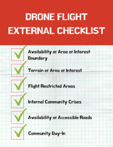
The Nigeria Flying Labs South West Hub team created a well-detailed project plan before launching this project to track milestones and identify risks. This stage includes the project inception report, budget, the drone flight checklist, the drone flight project checklist, and community engagement. The drone flight checklist considered factors internal to the project, such as the equipment status. In contrast, the drone flight project checklist considers factors external to the project, such as security, road access, environmental conditions, etc. External factors affect and determine a drone project's critical success factors. These factors should be documented and communicated, especially when engaging with the host community.
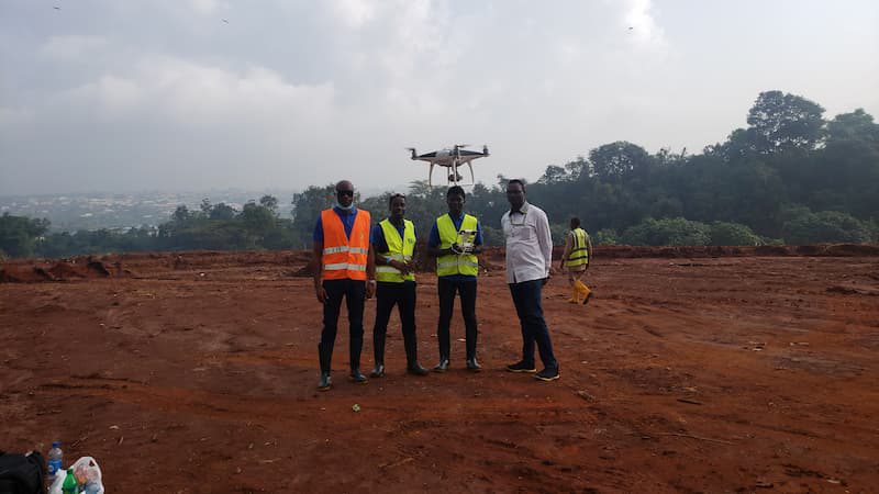
The journey by road to Benin City in Edo State, from Akure and Lagos, took 4 to 6 hours. On arrival, our team of 3, a drone pilot, assistant drone pilot, and supervisor, were received by the NEWMAP team and assigned a contact to accompany us to the freshly-cleared site. Rain from the previous day softened the soil so much that our feet sank into the soaked earth right up to our ankles. Without rain boots, it would have been a disaster (this is where the project checklist came in handy). After engaging with the community stakeholders, the team conducted a reconnaissance survey to get to know the area of interest and develop a drone flight base map.
We expected the following outputs:
- 2cm GSD orthomosaic GeoTIFF format,4cm GSD DSM Geotiff format,20cm DTM Geotiff format, Densified point cloud .las format.
- 3D textured mesh .obj format and data delivery through cloud hosting of the RAW drone imagery in JPEG format imagery, a 2cm GSD orthomosaic GeoTIFF format, a 4cm GSD DSM Geotiff format, a 20cm DTM Geotiff format, a Densified point cloud .las format, and a 3D textured mesh .obj format.
The drone flight was done in four phases based on the AOI uploaded to Pix4Dcapture. This took two days and covered a hundred hectares. To ensure no areas were excluded, we deliberately extended the flight plan to cover areas outside the area of interest. Sharing the data output was challenging due to Benin's poor network access and at our office in Akure. The poor bandwidth and high resolution of the drone imagery made data transfer difficult.
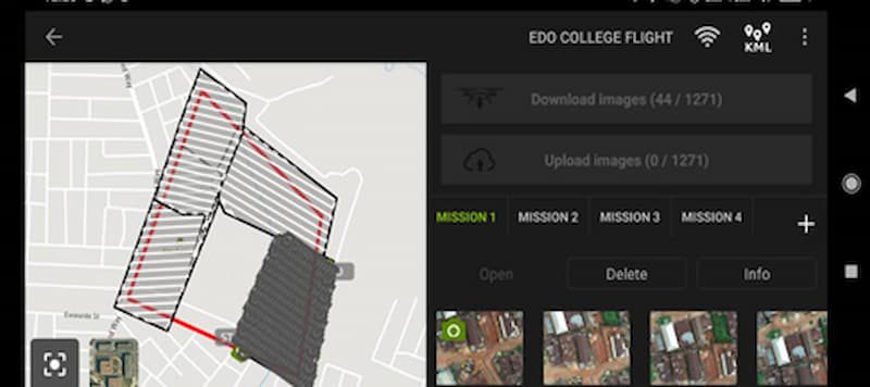
Drone flight in four phases based on the area of interest uploaded to Pix4Dcapture
The geology of the study area reveals that sedimentary rocks underlie the entire region. It consists of the crystalline basement rocks in the north's hilly and dissected zone, followed southwards by residual lateritic soils of the well-drained drylands. The NEWMAP project is in line with the growth and resilience goals of Nigeria's Vision 20:2020.
Drone outputs derived using Pix4Dmapper.
We thank WeRobotics for their faithful support and engagement and encourage our readers to share their thoughts and questions with us via Twitter or Facebook.


