
Mauritania Flying Labs Joins the Network
Flying Labs Network | July 20, 2026
The establishment of Mauritania Flying Labs creates a platform for long-term innovation, responsible technology use, and sustainable development impact.
For our Turning Data Into Action project, Burkina Faso Flying Labs sought to answer the question: Why adopt drone tech in the management of irrigated schemes?
November 27th, 2023
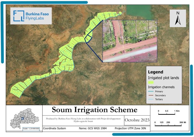
Remarkable agricultural transformation is underway in the village of Soum in Boulkiemdé province, Burkina Faso. Here, a large-scale agricultural development project implemented by the Projet de Développement Hydroagricole de Soum (PDHS) presents a dynamic response to the evolving challenges posed by climate change. This impressive agricultural facility covers an area of over 1,000 hectares spread over three sectors and irrigated by a dam with a capacity of 155 million cubic meters of water.
According to sources from VERTIGO, an environmental science journal, West African farmers have experienced a 30-50% decline in agricultural yields primarily due to erratic rainfall and persistent drought, among other factors. The promotion of irrigated agriculture by the government of Burkina Faso is a resilience strategy in response to the consequences of climate change.
As a beneficiary of the Turning Data Into Action (TDIA) microgrant facilitated by WeRobotics, Burkina Faso Flying Labs was keen to collaborate with PDHS as part of this project in order to jointly answer a pivotal question: Why adopt drone technology in the management of irrigated schemes in Burkina Faso?
 Aerial view of Soum irrigation scheme
The challenge, in other words, was to identify innovative drone tech applications in line with the needs and resources of Burkinabe public authorities. This is the essence of the WeRobotics Turning Data into Action (TDIA) program, a project management approach focused on the production of useful, actionable data. To this end, the program focuses on mobilizing stakeholders, so that they become active artisans of the solution they want to see developed. In the course of this journey of drone tech for social development, this co-investigation has given rise to two major areas of work, which we outline below.
The first application takes place during development work. By definition, an irrigated perimeter is a plot of land with an irrigation network, conveying water to agricultural plots. Creating an irrigated perimeter is a complex task. Where to excavate, where to backfill, what slope gradient to seek in order to obtain the right slope profile? The answers are provided by topographical studies, which are particularly crucial for this type of infrastructure.
 Topographic survey using aerial photogrammetry
The topographical engineer who piloted the development of the agricultural perimeter helped us conduct an experimental study, comparing conventional topographical survey methods with those based on drone technology.
 What followed was a revelation. Flying at an altitude of 110 meters, drone technology delivered the topographic profile of a plot of land with 5 centimeters of absolute accuracy, which, according to the topographical manager, was more than adequate for a development project. The result was an astounding 80% reduction in the budget allocated for topographic studies, while maintaining a qualitative result and delivering in a much shorter time frame.
The accompanying chart shows a comparison between the resources required to extract the topographic profile of a plot of land, using the conventional method (employed by the PDHS) and that of our team, which relies instead on aerial photogrammetry to carry out topographic surveys.
 There is often a gap between the design plan and the actual construction, due in part to the hazards of the terrain. Any planning activity in terms of crop management and monitoring therefore remains an approximation. However, one of the greatest strengths of drone tech is its ability to provide localized, up-to-date information, making it an excellent decision-making tool.
As part of the project, 800 hectares of irrigated plots were mapped to provide a true representation of the site. The drone data was then further exploited using Geographic Information Systems (GIS) to provide the unit responsible for providing technical support to farmers with a relevant decision-support tool. The following are various ways and means identified by the agricultural advisory unit itself to take advantage of the technology.
The accurate area data provided by the orthomosaic enables agricultural advisors to better organize input management, forecast crop yields, identify under-producing plots, and develop an appropriate response strategy.
 Training of the agricultural advisory unit in the administration of a spatial database
Some of the infrastructure within the irrigation scheme is designed to drain excess water into natural drainage areas, to prevent flooding of agricultural plots. However, if their retention capacity is exceeded in the event of heavy flooding, neighboring agricultural plots can quickly be inundated. This parameter must therefore be taken into account when deciding which crops to grow on these agricultural plots. To facilitate decision-making by the agricultural advisory unit, we created a buffer zone around the various structures, based on the orthomosaic provided by the drone. Plots located within the perimeter of these buffer zones were then defined as floodable in the spatial database. In this way, the agricultural advisory service can suggest to the owners of these plots that they opt for particular crops (instead of onions, growing vegetables or rice, for example).
Growers much prefer chemical fertilizers, which offer higher yields in the short term but cannot support sustainable production, not to mention the health risks incurred by consumers. The farm advisory unit will rely on a thematic map showing the correlation between plot yields and the use of organic fertilizers. This more digestible representation of statistical data could well change the game.
By taking into account specific parameters relating to an irrigated plot, such as surface area, soil type, type of crop grown and the flow rate of the canal irrigating the plot, the PDHS team can determine the irrigation time required for good production. On the other hand, it's tedious work to rely on charts to plan the water cycle. Based on the orthomosaic and these parameters, we have therefore created thematic maps which, for the entire perimeter, will indicate the irrigation time for each sector and can drastically reduce conflicts between producers.
This research comes at the end of the development phase, so other relevant applications of drone tech could not be explored, notably during the environmental impact assessment phases of development work, which is, of course, a subject we would be happy to explore further in the future.
 The power of local
With the right tools and approaches, drone tech, backed up by expertise, GIS, and photogrammetry, is an excellent tool for agricultural councils, providing localized information in real-time. Drone technology is particularly flexible, and as this investigation shows, possible applications depend on the needs of the players involved. Significantly less expensive than conventional terrestrial surveying techniques, drone surveys can considerably reduce the cost of development projects. Promoting this technology on a strategic scale could accelerate the implementation of agricultural development projects, a lever for sustainable development in sub-Saharan countries, all of which are prey to the vagaries of the climate.
The support of WeRobotics and the commitment of the Projet de Développement Hydroagricole Soum have enabled us to bring this research to a successful conclusion, in line with the current strategic needs of Burkina Faso and sub-Saharan Africa in general, which must take advantage of the potential of new technologies to initiate sustainable development.
Une transformation agricole remarquable est en cours autour du barrage hydro-agricole de Soum, dans la province du Boulkiemdé, au Burkina Faso. Ici, un projet de développement agricole à grande échelle mis en œuvre par le Projet de Développement Hydroagricole de Soum (PDHS) présente une réponse dynamique aux défis évolutifs posés par le changement climatique. Cette impressionnante installation agricole couvre une superficie de plus de 1 000 hectares répartis sur trois secteurs et irrigués par un barrage d'une capacité de 155 millions de mètres cubes d'eau.
Selon des sources provenant de VERTIGO, une revue scientifique environnementale, les agriculteurs d'Afrique de l'Ouest ont connu une baisse de 30 à 50 % des rendements agricoles, principalement en raison de l'irrégularité des précipitations et de la persistance de la sécheresse, entre autres facteurs. La promotion de l'agriculture irriguée par le gouvernement du Burkina Faso constitue en ce sens une stratégie de résilience développée pour faire face aux conséquences du changement climatique.
En tant que bénéficiaire de la micro-subvention Turning Data Into Action (TDIA) facilitée par WeRobotics, Burkina Faso Flying Labs a souhaité collaborer avec le PDHS dans le cadre de ce projet afin de répondre conjointement à une question clé : Pourquoi adopter la technologie des drones dans la gestion des périmètres irrigués au Burkina Faso?
Vue aérienne du périmètre irrigué de Soum
Il s’agit en d'autres termes d'identifier des applications innovantes de la technologie des drones en adéquation avec les besoins et les ressources des pouvoirs publics burkinabés. C'est l'essence même du programme TDIA, une approche de gestion de projet axée sur la production de données utiles et exploitables. Pour ce faire, le programme met l'accent sur l’engagement et la mobilisation des parties prenantes, afin qu'ils deviennent les artisans actifs de la solution qu'ils souhaitent voir le Flying Labs mettre en place. Au cours de ce voyage de la technologie des drones au service du développement social, cette co-investigation a fait germer deux grands axes de travail que nous vous exposons ci-après.
La première application intervient au stade des travaux d'aménagement. Par définition, un périmètre irrigué est une terrain disposant d’un réseau d’irrigation, acheminant l'eau vers les parcelles agricoles. Compte tenu des superficies dont il est question, il s’agit bien d’une tâche complexe. Où excaver, où remblayer, quelle pente rechercher afin d’obtenir le bon profil de talus ? Les réponses sont apportées par les études topographiques, de fait particulièrement cruciales pour ce type d'infrastructure.
L'ingénieur topographe ayant piloté les travaux d’aménagement de Soum a appuyé notre équipe dans la réalisation d’une étude comparative, confrontant les méthodes de relevé topographique conventionnelles à celles basées sur la technologie des drones.
Levé topographique par photogrammétrie aérienne
La suite a été une révélation. Volant à une altitude de 110 mètres, la technologie des drones a fourni des résultats avec une précision horizontale et verticale absolue de près de 5 centimètres, ce qui, selon le responsable topographique, était plus qu'adéquat pour un projet d’aménagement.
 Le graphique suivant montre une comparaison entre les ressources nécessaires pour extraire le profil topographique d'une parcelle, en utilisant la méthode conventionnelle (employée par le PDHS) et celle de notre équipe, qui s'appuie plutôt sur la photogrammétrie aérienne.
On peut affirmer que l’implémentation de la technologie des drones dans un projet d’aménagement permettrait de faire une économie de plus de 80% sur le budget alloué aux études topographiques.
 Il y a souvent un gap entre le plan de conception et la construction effective, en partie à cause des aléas du terrain. Toute activité de planification en termes de gestion et de suivi des cultures reste donc une approximation. Or, l'un des principaux atouts de la technologie des drones est sa capacité à fournir des informations localisées et actualisées, ce qui en fait un excellent outil d'aide à la décision.
Dans le cadre du présent projet, 800 hectares de parcelles irriguées ont été cartographiés afin d'obtenir une représentation fidèle du site. Les données du drone ont ensuite été exploitées à l'aide de Systèmes d'Information Géographique afin de fournir à la cellule chargée de l'appui et conseil technique aux agriculteurs un outil d'aide à la décision pertinent. Voici les différents moyens identifiés par l'unité de conseil agricole elle-même pour tirer profit de la technologie.
L’orthomosaïque du périmètre aménagé fournit des données de surface précises de, permettant aux conseillers agricoles de mieux organiser la gestion des intrants, de prévoir les rendements des cultures, d'identifier les parcelles sous-performantes et d'élaborer une stratégie d'intervention appropriée.
Certaines infrastructures du périmètre aménagé sont conçues pour drainer l'excès d'eau vers les zones de drainage naturel, afin d'éviter l'inondation des parcelles agricoles. Dès lors que leur capacité de rétention est excédée lors de crue trop importantes, les parcelles agricoles voisines peuvent vite être inondées. Il faut donc tenir compte de ce paramètre lors du choix des cultures à cultiver sur ces parcelles agricoles. Afin de faciliter la prise de décision de l’unité du conseil agricole, nous avons créé sur la base de l'orthomosaïque fournie par le drone, une zone tampon autour des différentes colatures. Les parcelles situées dans le périmètre des différentes zones tampons ont ensuite été définies comme inondables dans la base de données spatiale. De cette manière, la cellule de conseil agricole peut suggérer aux propriétaires de ces parcelles d'opter pour des spéculations particulières (au lieu de l’oignon, plutôt des cultures maraîchères ou de la riziculture par exemple).
Formation de la cellule de conseil agricole à l'administration d'une base de données spatiales
Les producteurs préfèrent de loin les engrais chimiques, qui offrent des rendements plus élevés à court terme mais ne peuvent soutenir une production durable, sans parler des risques sanitaires encourus par les consommateurs. L'unité de conseil agricole s'appuiera sur une carte thématique montrant la corrélation entre les rendements des parcelles et l'utilisation d'engrais organiques. Cette représentation plus digeste des données statistiques pourrait bien changer la donne.
En prenant en compte des paramètres spécifiques à une parcelle irriguée, tels que la surface, le type de sol, le type de culture et le débit du canal irriguant la parcelle, l'équipe du PDHS peut déterminer le temps d'irrigation nécessaire à une bonne production. Toutefois, il est fastidieux de s'appuyer sur des graphiques pour organiser. A partir de l'orthomosaïque et de ces paramètres, nous avons donc créé des cartes thématiques qui, pour l'ensemble du périmètre, indiqueront le temps d'irrigation pour chaque secteur et pourront réduire drastiquement les conflits entre producteurs.
Cette recherche se situant à la fin de la phase de développement, d'autres applications pertinentes de la technologie des drones n'ont pas pu être explorées, notamment lors des phases d'évaluation de l'impact environnemental des travaux d’aménagement, un sujet que nous serions bien sûr heureux d'approfondir à l'avenir.
Le pouvoir du local
Avec les bons outils et les bonnes approches, la technologie des drones, renforcée par l'expertise, les SIG et la photogrammétrie, est un excellent outil pour le conseil agricole, car elle fournit des informations localisées en temps réel. La technologie des drones est particulièrement flexible et comme le montre cette investigation, les applications possibles dépendent des besoins des acteurs. Significativement moins onéreuse que les techniques de levé topographique terrestre conventionnel, les levés par drone peuvent réduire considérablement le coût des projets d'aménagement. La promotion de cette technologie à l’échelle stratégique pourrait accélérer la mise en œuvre des projets d’aménagement, levier du développement durable dans les pays subsahariens, tous en proie aux caprices du climat.
Le soutien de WeRobotics et l'engagement du Projet de Développement Hydroagricole Soum nous ont permis de mener à bien cette recherche, en phase avec les besoins stratégiques actuels du Burkina Faso et de l'Afrique subsaharienne en général, qui doivent tirer profit du potentiel des nouvelles technologies afin d’amorcer un développement durable.

