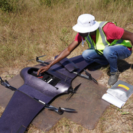
Assessment of Land Degradation in the Zambezi Region
This project showcased how drone-enabled technology can empower Namibia’s environmental governance, enabling data-driven responses to land degradation
May 22nd, 2025
Namibia Flying Labs led a critical land degradation assessment project in the Zambezi Region as part of a broader climate action initiative. With support from multiple stakeholders, including the Ministry of Environment, Forestry and Tourism (MEFT), the Namibia Civil Aviation Authority, and the University of Namibia, the project sought to address the urgent need for sustainable land management in northern Namibia, where poverty, biodiversity loss, and deforestation are growing concerns. Key insights revealed the potential of drone data to support environmental decision-making and inform a long-term action plan for landscape restoration and sustainable livelihoods.

Discover the use case
Download
Category(s)
Location(s)
Recent Articles
View All »

Team Cameroon's Road to Victory at the First Global Robotics Competition 2025
