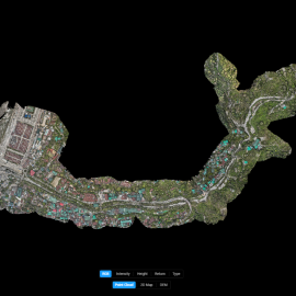
Aerial LiDAR-based Topographic Survey of Omchhu River Basin.
Significant outcome of the project is the establishment of a reliable data baseline that informs local planning.
May 22nd, 2025
Bhutan Flying Labs conducted a cutting-edge aerial LiDAR-based topographic survey of the Omchhu River Basin in Phuentsholing. This initiative, carried out in partnership with Phuentsholing Thromde and supported by the Asian Development Bank, aimed to address the municipality’s limited disaster preparedness and poor early warning systems, critical gaps that have hindered climate-resilient infrastructure development and sustainable watershed planning. The data collection process, completed in just 30 minutes, delivered a granular ground sampling distance of 2.2 cm/pixel and enabled the creation of detailed orthomosaics, Digital Terrain Models (DTM), and elevation profiles. These outputs offered new visibility into river morphology, erosion-prone zones, and land use patterns that were previously unmapped at such precision.

Discover the use case
Download
Category(s)
Location(s)
Recent Articles
View All »

Team Cameroon's Road to Victory at the First Global Robotics Competition 2025
