A Literal Record Number of Pollution Images Were Captured in Lima
Peru Flying Labs' photogrammetric survey to make visible the pollution on the coast of Lima will enable the local community to take environmental action.
March 30th, 2023
The global drone service provider GLOBHE, alongside its Crowddroning community, set the challenge to collect as much aerial imagery as possible to create an orthomosaic showcasing of the visible effects of climate change in different parts of the world. With this goal in mind, 96+ countries collaborated to break a world record despite weather conditions, blizzards, and holidays.
Thanks to the collaboration of Globhe Drone AB from Sweden and the Crowddroners community worldwide, a ‘World Guinness Record’ was achieved. During two months, from December 10, 2021, to February 10, 2022, the community, consisting of 5 000+ operators from 96 countries, could compile 22,909 images.
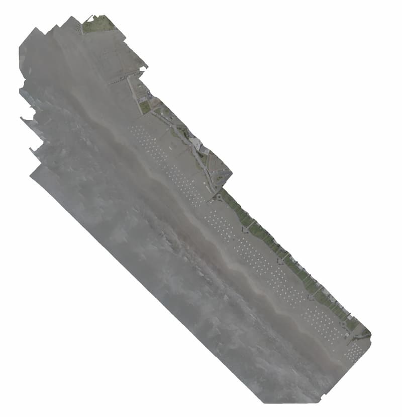
Peru Flying Labs, hand in hand with UAVs from Peru, were able to carry out a photogrammetric survey to make visible the pollution on the coast of Lima, more precisely, in Chocalla Beach. We had to ensure appropriate weather conditions for the drones to fly in the coastal area since the project was carried out during the foggy season.
 Orthomosaic obtained from the processing of the captured images
This project was carried out in a single day; the team traveled south of Lima for more than 1 hour and a half. The area consisted of 21 hectares, in which the drone collected a dataset of 329 raw images approximately.
The information obtained is intended to assess the contamination of the area covered. In addition, this processed data can be used for documentation and awareness purposes. In this way, the community in the area takes environmental action.
The work carried out is part of a long-term goal of this global initiative to present the data collected as a tool for documenting the diverse effects of climate change in different parts of the world. Also, highlight areas that could be more frequently displayed in the media, like our country, to showcase the local impact and boost environmental projects. We want to thank every entity involved in this ambitious challenge and GLOBHE for impulsing initiatives that helped raise environmental awareness.
Peru Flying Labs Recolecta Imágenes de la Contaminación en la Costa de Lima Para Contribuir en Un Récord Guinness Mundial
El proveedor global de servicios de drones, GLOBHE, junto con su comunidad de drones colaborativa, estableció el desafío de recolectar la mayor cantidad de imágenes aéreas posibles para crear un ortomosaico que muestre los efectos visibles del cambio climático en diferentes partes del mundo. Con este objetivo en mente, más de 96 países colaboraron para romper un récord mundial, a pesar de las condiciones climáticas, las tormentas de nieve y los días festivos.
Gracias a la colaboración de Globhe Drone AB de Suecia y la comunidad de Crowddroners de todo el mundo, se logró un 'Récord Guinness Mundial'. Durante dos meses, desde el 10 de diciembre de 2021 hasta el 10 de febrero de 2022, la comunidad, compuesta por más de 5,000 operadores de 96 países, pudo recopilar un total de 22,909 imágenes.
Peru Flying Labs, en colaboración con UAV de Perú, pudo llevar a cabo un relevamiento fotogramétrico para hacer visible la contaminación en la costa de Lima, más específicamente, en la Playa Chocalla. Para que los drones pudieran volar en la zona costera, fue necesario asegurarse de que hubiera condiciones climáticas apropiadas, ya que el proyecto se realizó durante la temporada de niebla.
 Orthomosaic obtained from the processing of the captured images
Este proyecto se llevó a cabo en un solo día, el equipo viajó al sur de Lima durante más de 1 hora y media. La zona constaba de 21 hectáreas en las que el dron recopiló un conjunto de datos de aproximadamente 329 imágenes en bruto.
Con la información obtenida, se pretende evaluar la contaminación en el área cubierta. Estos datos procesados se pueden utilizar con fines de documentación y concienciación. De esta manera, la comunidad que reside en la zona toma medidas ambientales.
El trabajo realizado forma parte de un objetivo a largo plazo de esta iniciativa global para presentar los datos recopilados como una herramienta para documentar los diversos efectos del cambio climático en diferentes partes del mundo. También para llamar la atención sobre áreas que no se muestran con frecuencia en los medios de comunicación, como nuestro país, con el fin de impulsar proyectos ambientales. Queremos agradecer a todas las entidades que participaron en este ambicioso desafío y a GLOBHE por impulsar iniciativas que ayuden a aumentar la conciencia ambiental.
Category(s)
Location(s)
Recent Articles
View All »

Wildfire Assessment and Web Application in Sao Paulo
