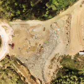
Volumetric Analysis of Waste Management of Memelakha
Bhutan Flying Labs conducted a groundbreaking project in collaboration with Thimphu Thromde to address pressing challenges at the Memelakha landfill in Thimphu
May 1st, 2025
Bhutan Flying Labs successfully generated accurate volumetric data of the Memelakha landfill using drone-based 3D mapping. This enabled effective waste monitoring and supported data-driven decisions for sustainable landfill management. In the future, the drone-based monitoring system will aim to be integrated into regular landfill management and expanded to other waste sites in Bhutan.
This data-driven approach marked a significant improvement in waste management practices. With only 30 minutes of flight time, 50 high-resolution images covering 200 hectares were collected and processed into actionable insights using DroneDeploy and Pix4Dreact. The project outputs—such as orthophotos and digital elevation models—were shared with local authorities to guide future landfill operations.

Discovoer the use case
DownloadCategory(s)
Location(s)
Recent Articles
View All »

Wildfire Assessment and Web Application in Sao Paulo
