South Africa Flying Labs Responds To Devastating Floods Using Drones
In the aftermath of devastating floods SA Flying Labs carried out the second phase of their Turning Data Into Action project – a change detection exercise.
September 13th, 2023
The South African government declared a State of Disaster on the 13th of February, 2023. This declaration followed heavy rainfall caused by the La Nina weather phenomenon, which affected seven out of the nine provinces in South Africa. Parts of the country experienced devastating floods due to torrential rains in February. Lives were lost, houses and public infrastructure were damaged, and economic and social activities were adversely affected.
 These events—a heatwave followed by torrential rains—have led to flooding in the Southern African Development Community (SADC) region in South Africa. This has brought disaster management back onto the agenda following two years of a deadly pandemic. Quick and effective measures were necessary to mitigate the impact of the disaster.
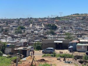
In the wake of this, South Africa Flying Labs and QP Drone Tech, in partnership with UNICEF South Africa, Santam, and WeRobotics, came together to map and assess the damage caused by heavy rainfall along the Jukskei River in Alexandra, a township in the City of Johannesburg, Gauteng Province. This mission was part of South Africa Flying Labs' second phase of the Turning Data into Action (TDIA) project.
The Turning Data into Action project"Turning Data into Action" is an initiative by WeRobotics that presents an opportunity to use generated data to inform planning and decision-making and reduce the impact of disasters in the future. The project aims to provide Flying Labs with tools and techniques to facilitate a positive impact by enhancing stakeholders' ability to read and use drone data. More than anything, it gives a great platform to achieve this with the involvement of community members, local authorities, strategic partners, and relevant stakeholders, thus emphasizing "The Power of Local."
 The first phase of the TDIA project, which we carried out in June 2022, entailed a risk mitigation exercise. During this phase, we mapped an area in Alexander to identify vulnerable areas most likely to be affected by disasters. In the aftermath of the floods in February 2023, we carried out the second phase, a change detection exercise.
Uncovering vulnerabilities amidst the deluge
At least seven of the country's provinces were affected by these devastating floods. Bridges collapsed in villages, cutting off areas and people. Learners, particularly, could not access their schools, and workers were impeded from earning a livelihood. Dwellings were flooded, resulting in damage to household equipment and other amenities, as well as rendering the houses uninhabitable.
This exposed our level of unpreparedness to deal with disasters of this scale and form and highlighted the need to combine conventional methods of disaster response with modern technologies to enhance efficiency and safety.
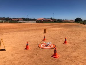
After two weeks of productive stakeholder engagements and community meetings, we were finally granted permission to deploy drones for this purpose. An area of 146 hectares was surveyed using drone technology to confirm previous findings and assess the damage caused by torrential rains. These findings were then compared with the results from the first phase of the TDIA project and presented to the various stakeholders involved in the decision-making process to highlight the differences.
This is what the second phase uncovered: various infrastructures have been altered or completely demolished, dumping areas have increased in size, and the average water level in the Jukskei River has risen by 0.5 meters due to recent flooding and rain, causing vegetation growth, which makes the nearby dwellings vulnerable to fire when it dries.
According to an article by the International Federation of Red Cross and Red Crescent Societies (IFRC), "A total of 4,709 households (16,177 people) have been affected. From the 11th of December to date, flooding incidents in the seven provinces have affected a total of 56,177 people (40,000 people from the 11th of December and 16,177 people from the recent floods)."
Redefining disaster response using drones
That drones are progressively being deployed in disaster situations shows that they can be used not only to assess and quantify damage but also to monitor recovery efforts and reconstruction activities. As an example, drone technology and other cutting-edge technologies were utilized to save millions of lives during Cyclone Eloise.
Redefining disaster response calls for innovative ways of accessing information about infrastructure damage, communicating with the public, ensuring timely early warnings, and managing evacuations. Without this elevated efficiency, we continue to risk the loss of lives and property, with communities facing prolonged isolation, disruption, and damage in the aftermath of calamities.
The success of the first phase of the TDIA project led to many interventions, including the second phase. Notably, it also led to the first Drones in Disaster Management Conference held in October 2022. The conference saw industry experts, government officials, private sectors, and UN agencies, among others, share insights and best practices for using drones and robotics for disaster management, preparedness, and response. The second installment of the conference will occur on the 1st and 2nd of November, 2023.
Another initiative that the TDIA project has had a ripple effect on is the launch of accredited training in disaster management for unemployed youth. The unemployed youth who participated in the first and second phases of the TDIA project were trained to become disaster management champions in Alexandra. The community's resilience was palpable, underscoring the project's enduring impact. Moreover, South Africa Flying Labs and QP Drone Tech are emerging as thought leaders in integrating drones and robotics into disaster management and response.
Shaping tomorrow from the skies
The aftermath of the floods revealed both the fragility of human settlements in the face of nature and the power of human ingenuity and collaboration as we rise to rebuild. This project demonstrated the ability to wield drones and data to shape the future, and it will continue to create a sustainable impact on the vulnerable local communities that often bear the brunt of these disasters. Committed to building on this work, South Africa Flying Labs looks towards a future where drones uplift communities and safeguard lives.
Category(s)
Location(s)
Recent Articles
View All »

Wildfire Assessment and Web Application in Sao Paulo
