Jamaica Flying Labs: Official Training Partner for HOT’s Drone Task Manager
Drone TM is a powerful tool that streamlines drone mapping workflows, designed for communities working at the forefront of disaster resilience and development.
November 26th, 2024
We’re thrilled to announce that Jamaica Flying Labs is now the official training partner for the Drone Task Manager (Drone TM). This collaboration represents an important step toward empowering Caribbean communities and stakeholders with the skills and tools to harness drone technology for essential mapping and data analysis, ultimately enabling more effective disaster response, regional planning, and environmental monitoring.
The Drone Task Manager is a project spearheaded by the Humanitarian OpenStreetMap Team (HOT) and funded by the Global Facility for Disaster Reduction and Recovery (GFDRR). Developed by NAXA with strategic input from Jamaica Flying Labs, Drone TM is a powerful tool that streamlines drone mapping workflows, from mission planning to data collection and processing. Designed specifically for communities working at the forefront of disaster resilience and development, Drone TM provides access to reliable geospatial data—a critical asset in emergency management and long-term regional development. As the official training partner, Jamaica Flying Labs is excited to bring this technology to a broader audience, offering hands-on experiences that empower users to implement drone-based mapping solutions with confidence.
Why Drone TM?
Drone TM prioritizes simplicity and accessibility, making it suitable for users from diverse backgrounds, whether they are experienced GIS professionals or new to drone technology. By enabling users to plan, execute, and process drone mapping missions on a single platform, Drone TM offers a seamless experience that enhances situational awareness, data accuracy, and response times during emergencies. This efficient approach is invaluable for communities with limited resources, allowing them to maximize the impact of drone technology without the need for complex software or extensive training. For more information on Drone TM visit https://dronetm.org/ .
Jamaica Flying Labs’ Role as the Training Partner
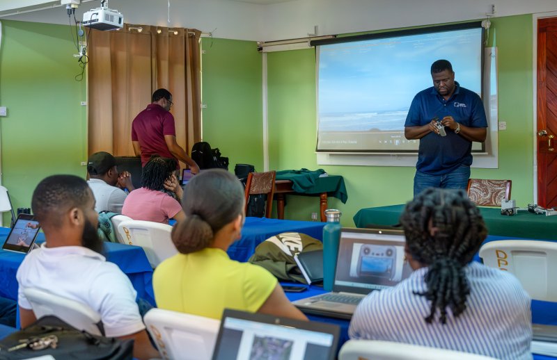
As the official training partner, Jamaica Flying Labs has already led two hands-on training sessions in the Caribbean—one in Dominica and another in St. Lucia. These sessions introduced local communities to Drone TM’s capabilities, empowering participants to leverage drone mapping for their unique needs. The training program is built on a foundation of real-world applications, covering:
- Drone Piloting and Mission Planning: Participants learn the essentials of drone flight, mission design, and pre-flight preparations.
- Drone TM Software Mastery: Comprehensive sessions on setting up projects, creating waypoints, processing data, and generating high-quality geospatial outputs.
- Field-Based Exercises: Real-world mapping missions that give participants practical experience, from capturing high-resolution imagery to creating orthophotos and 3D models.
The training also emphasizes compliance with local Civil Aviation Authority (CAA) guidelines, ensuring safe and responsible drone use aligned with Caribbean regulatory standards.

Addressing Local Needs with Tailored Support
Jamaica Flying Labs is dedicated to tailoring each training session to meet the unique needs of its Caribbean partners. For communities in disaster-prone areas, Drone TM offers the ability to quickly map and assess the impact of events like hurricanes, floods, and landslides. This partnership also supports local development initiatives, from urban planning to environmental conservation, by equipping participants with the skills to collect and analyze data that informs sustainable decision-making.
To further support users after training, Jamaica Flying Labs is exploring the option of hosting monthly open consultation calls for ongoing technical support and advice. These sessions will provide a platform for participants to address specific questions and share experiences, fostering a community of practice around drone-based mapping. Stay tuned for more information on this.

A Collaborative Future
We extend our thanks to our partner HOT for trusting us to deliver these essential training sessions and for their ongoing commitment to advancing open mapping capabilities globally. We’re especially pleased to see this commitment expand into the realm of drone technology for the Caribbean. We also express our gratitude to the GFDRR for recognizing the tremendous value that an open drone mapping community can bring to the region. Together, we are building a resilient and connected future, one mapping mission at a time.
As we continue to expand this training program, we look forward to seeing how communities will harness this technology to strengthen resilience, support recovery, and foster sustainable development. With our combined expertise and commitment, we’re empowering a new generation of drone operators to transform how their communities gather and use data for a better future.
Category(s)
Recent Articles
View All »

Team Cameroon's Road to Victory at the First Global Robotics Competition 2025
