Benin Flying Labs Hosts Students for the First National Cartography & Robotics Competition
The contest encouraged children’s creative vision of the world while familiarizing them with the cartographic representation of their environment.
July 29th, 2021
Cartography brings science, technology, and art together for cartography in detailed and beautiful depictions of the Earth. Cartography has evolved significantly over time. Today, we have a multitude of thematic maps that, while highlighting the planet's organization and dynamics, allow us to understand the world better, study and analyze the phenomena more easily, and make smarter decisions.

Consequently, the map helps us reconstruct our conception of space, have a broader vision of our environment, and our position in it. So the translation from the 3D natural world to a 2D map is crucial in constructing the abstraction faculties of children. Moreover, with the advent of drones, data and imagery for map-making have become much faster and easier. From the sky, drones offer us a global and detailed view of our territory, a magnificent landscape.
To integrate cartography and new technologies into the daily lives of children, Benin Flying Labs, in partnership with ATLAS-GIS, the Beninese Association of Cartography and Geographic Information (ABCIG), and the Beninese Association of Professionals and Amateurs of Drones (ABePA-Drone), organized the first edition of the National Competition of Cartography and Robotics (CNCR) for primary and secondary school students: a challenge that led them, through mapping, to express themselves on given themes, combining imagination and creativity.
The main objective of this contest was to encourage children's creative vision of the world while familiarizing them with the cartographic representation of their environment. Specifically, it was to:
- Develop the child's imagination;
- Encourage the child to know their environment better, to value and to imagine it in color;
- To make the child aware of their importance within the environment in which they live;
- To allow the child to be aware of the different changes which take place in their environment and the evolution of technology;
- To educate the child in the language of cartography and the making of maps.
The competition was open to children under 16 years old and was divided into two groups: the first for juniors (ages 6 to 12) and the second for seniors (ages 12 to 15). The children had to choose between the following themes: "the world facing the COVID -19 pandemic," "let's protect our planet," "women in society," "use of drones in the world," "cities of the future," and "map of my neighborhood/village." The CNCR welcomed 393 participants, including 144 girls and 249 boys, and we received 276 entries in the end. For its inaugural run, the CNCR focused on three communes of Benin: Abomey-Calavi, Porto-Novo, and Cotonou.
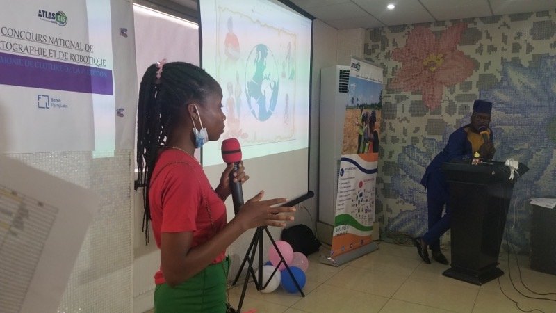
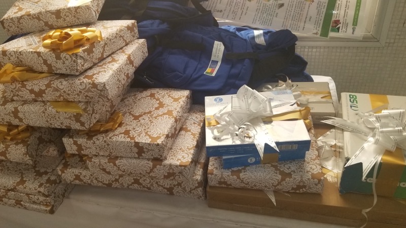
The competition launched on April 17 and concluded with an award ceremony on July 10, after careful work by a jury composed of experts in cartography, geography, and professors of the national university of Abomey-Calavi campus. During the ceremony, the winning children had to present their works, themes and talk about what motivated them to participate in the competition. The six best presentations were awarded the prizes listed below, and a hundred consolation prizes were distributed to encourage the participants.
Junior Category Prizes:
- 1st: A bike (theme: The world facing the Covid)
- 2nd: a Drone (theme: Protecting the planet)
- 3rd: a Tablet (theme: The world facing the Covid)
Senior Category Prizes:
- 1st: a Computer (theme: Protect the Planet)
- 2nd: a Drone (theme: The world facing the Covid)
- 3rd: a Tablet (theme: Let's protect the planet)
At the end of the ceremony, which took place at the Majestik of Cadjehoun in the 12th district of Cotonou, the participants warmly expressed their gratitude for the organization of such an event that revealed the young's hidden talents Beninese generation.

Special thanks to the European Union, which provided 60 bags and caps as consolation prizes for the children. Furthermore, our thanks also go to the Beninese Association of Cartography and Geographic Information (ABCIG) and the whole team of Atlas-Gis. Also, we have received advice from WeRobotics regarding the approach and the essential documents related to the submission of the children's productions.
En français…
À la fois science, technique et art, la cartographie a pour but la représentation de la Terre sous une forme géométrique et graphique grâce à la conception, la préparation et la réalisation de cartes. La cartographie s’est développée au fil du temps et aujourd’hui, nous disposons d’une multitude de cartes thématiques qui, tout en mettant en évidence l’organisation de notre planète et les dynamiques qui la traversent, nous permettent de mieux comprendre le monde, de facilement étudier et analyser les phénomènes qui s’y produisent et de pouvoir prendre des décisions idoines.

Par conséquent, la carte aide l’enfant à reconstruire sa représentation de l’espace, elle lui permet d’avoir une vision large de son environnement, de pouvoir facilement s’y situer, lui procurant ainsi une réelle liberté. Le passage de la 3D du monde réel à la 2D de la carte est extrêmement important dans la construction des facultés d’abstraction des enfants.
Avec l’avènement des drones qui sont des engins volants sans pilote à bord, la collecte et l’acquisition des données pour l’élaboration des cartes deviennent beaucoup plus rapides et aisées. Du ciel, les drones nous offrent une vue globale et détaillée de notre territoire, un paysage magnifique.
Dans le souci d’intégrer la cartographie et les nouvelles technologies dans le quotidien des enfants, le Benin Flying Labs en partenariat avec ATLAS-GIS, l’Association Béninoise de Cartographie et de l’information Géographique (ABCIG) et l’Association Béninoise des Professionnels et Amateurs de drones (ABePA-Drone) ont organisé cette année, la première édition du Concours National de Cartographie et de Robotique (CNCR) pour des élèves du primaire et du secondaire : un challenge qui les a amené, grâce à la cartographie, à s’exprimer sur des thématiques données, en combinant imagination et créativité.
L’objectif principal de ce concours a été d’encourager la vision créative des enfants sur le monde tout en les familiarisant à la représentation cartographique de leur environnement.
De façon spécifique, il s’agissait de :
- Développer l’imagination de l’enfant ;
- Inciter l’enfant à mieux connaître son environnement, à le valoriser, à l’imaginer en couleur ;
- Amener l’enfant à prendre conscience de son importance au sein de l’environnement dans lequel il vit ;
- Permettre à l’enfant d’être au parfum des différents changements qui s’opèrent dans son environnement et de l’évolution de la technologie ;
- Instruire l’enfant au langage cartographique et à la réalisation des cartes.
Le concours était ouvert aux enfants de moins de 16 ans et était scindé en deux groupes : le premier réservé aux juniors (6 ans à 12) et le deuxième aux seniors (12 à 15). Les enfants ont eu à choisir entre les thèmes suivant : le monde face au Covid-19, protégeons notre planète, la femme dans la société, l’utilisation des drones dans le monde, les villes du futur, la carte de mon quartier / village. Le concours a été lancé le 17 avril et la cérémonie de remise de prix s’est déroulée le samedi 10 juillet après un travail minutieux d’un jury composé d’experts en cartographie, en géographie et des professeurs de l’Université Nationale du campus d’Abomey-Calavi.
Les six meilleures productions des enfants ont été primées et une centaine de lots de consolations remis dans le but d’encourager les participants. Au cours de la cérémonie, les enfants primés ont eu à présenter leurs œuvres, le choix du thème et leur motivation à participer au concours.
Pour cette première édition du CNCR, 393 participants dont 144 filles et 249 garçons se sont enregistrés et nous avons reçu 276 dessins au total. Le CNCR s’est concentré sur trois communes du Bénin pour ce premier concours: Abomey- Calavi, Porto-Novo et Cotonou.
Pour la catégorie Junior les prix sont :
- 1er prix: un vélo tout-terrain (thème abordé : Le monde face au Covid-19)
- 2ème prix: un Drone (thème abordé : Protégeons la planète
- 3ème prix : une Tablette (thème abordé : Le monde face au Covid-19)
Pour la catégorie Senior :
- 1er : Un ordinateur (thème abordé : Protégeons la planète)
- 2ème : un Drone (thème abordé : Le monde face au Covid-19)
- 3ème : une Tablette (thème abordé : Protégeons la planète)
Au terme de la cérémonie qui a eu lieu au Majestik de Cadjehoun dans le 12ème arrondissement de Cotonou, les participants ont chaleureusement exprimé leur reconnaissance pour l’organisation d’un tel événement qui a révélé les talents cachés de la jeune génération Béninoise.
Il serait judicieux de rappeler que l’organisation du concours n’a pas été un fleuve paisible mais elle a été parsemée de challenges comme le manque de sponsors et d’appui financier.

Nous tenons à remercier l’Union Européenne qui a mis à disposition 60 sacs et casquettes comme lots de consolation. Par ailleurs, nous remercions également l’Association Béninoise de Cartographie et de l'Information Géographique (ABCIG) ainsi que toute l’équipe de Atlas-Gis. Merci à l’équipe de WeRobotics pour leur soutien et conseils en rapport avec le concours.
Category(s)
Location(s)
Recent Articles
View All »

Team Cameroon's Road to Victory at the First Global Robotics Competition 2025

